Severe Thunderstorms Possible Tomorrow With Large Hail & Tornado Threat ⚡
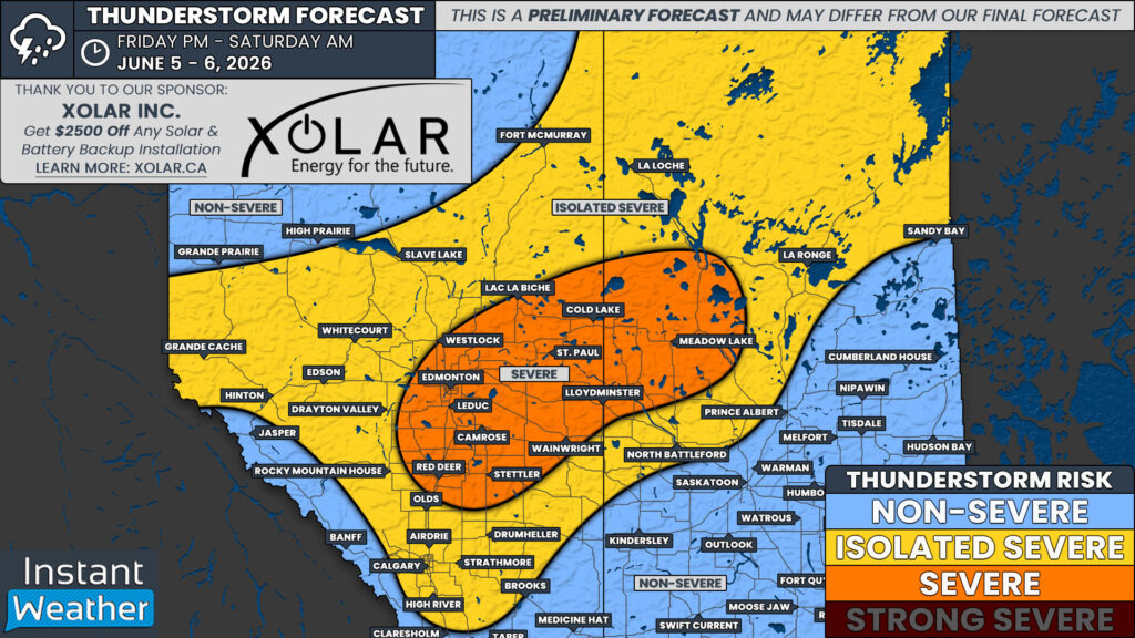
We’re keeping a very close eye on the possibility of some fairly strong severe thunderstorms that could impact parts of Alberta and Saskatchewan tomorrow. The greatest risk of severe thunderstorms is expected to stretch from Central Alberta into Northwestern Saskatchewan, where storms could possibly produce golf ball sized hail, damaging wind gusts, heavy rain, and maybe even a tornado.
The trigger for tomorrow’s thunderstorm development will be a cold front from a low that is set to strengthen through the day. Thunderstorms are expected to begin developing in the early afternoon; and weather models are currently suggesting that storms could fire up in the Foothills, East Central, and Northwestern Saskatchewan during this time.
The storms will gradually track northeastward through the afternoon and evening. It’s possible that some thunderstorms may persist into the overnight hours, but by this time, they should weaken to non-severe levels.
We’re sharing our preliminary forecast this evening, but we plan to have more details and a final map posted for you in the morning.
– Alannah
———
Thank you to our sponsor, Xolar: Energy For The Future ☀️⚡
Xolar Inc is a Canadian-owned solar installation company installing solar and battery backup for homeowners and businesses across Canada.
Right now, Xolar Inc is making an exclusive offer only to members of our Instant Weather community to get an additional $2500 off any solar and battery backup installation, on top of eligible provincial rebates available for solar + battery.
If you would like to claim this special $2500 Instant Weather offer, as well as eligible provincial rebates, request a solar + battery quote with Xolar Inc at the link below!
LEARN MORE: Xolar.ca/residential-solar-quote/?DLR00056
———


